Mile XIII NH Marker

The stone marker set in front of the Shed behind the Hitchcock-Phillips House is a Colonial Mile Marker. In 1767, the Colonial General Court enacted a law requiring orderly road markings. This law ordered “that milestones, at least two feet high, be set up by the Selectmen of the towns near the side of the common traveling roads and on the Post roads in every County marking the distance to the County town.” The “County town” was later revised to reference the “County Court House.” Since Cheshire was located in New Haven County, all milestones located within Cheshire used New Haven for their reference. Meanwhile, Cheshire’s neighbor to the north, Southington, lies within Hartford County. Therefore, milestones located in Southington marked the distance to Hartford County Court House.
While different types of stone were used, brownstone was the most common. By custom, the stones were installed on the right-hand side of the road leading to the County Court House. A 1951 essay reports that in the 1930s, the line of stones to New Haven “seems to end with stone No. 17, about one mile south of the trolley junction at Milldale.”
The Mile 13 marker’s original location was across the street from Cheshire High School. It had been moved from that location to a garden on Cornwall Ave., before it was donated to the Historical Society.
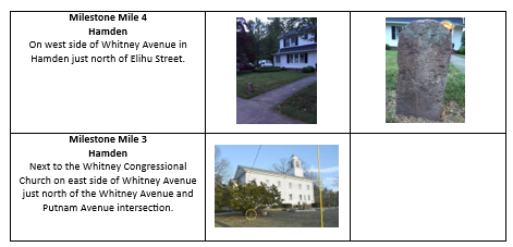
The following chart identifies the locations of the mile markers that can still be found (if you look closely enough) along Route 10 in Cheshire and Hamden.